Computer Aided Design:The Third Dimension
21 Jul 2020
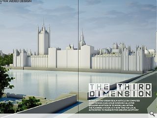
In this second Urban Realm article on Computer Aided Design (CAD) Leslie Howson calls for broader adoption of 3d modelling within the planning system. Is it now time for local authorities to mandate for greater adoption?
The most effective way to communicate architectural and urban design proposals is undoubtedly interactive CAD modelling. The process of obtaining permission to build can be long and complex, often involving several abortive planning submissions and much time and resources spent by professionals and planning departments which, especially for cash strapped local authorities, is an ever-growing problem.
We all experience the world in three dimensions, yet most planning submissions are presented using two-dimensional drawn information supplemented by reports and design statements. Planning officers pouring over submissions have to interpret mostly flat information three-dimensionally, whilst in many cases not having actual 3D imagery in front of them. Whilst planning officers are in general trained for that task and under delegated powers can make an informed judgment, most larger projects ultimately go before planning committees consisting largely of laypersons untrained in design.
There are suggestions in certain quarters of the planning system, that councillors, community councils and even some planning officers and reporters, should receive design training to better equip them to make informed judgements about what is put before them. Surely, the clearer the information submitted, the easier it is for the decision-makers to carry out their role, leaving no room for ambiguities or need to interpret the nature of the design proposals.
The design process starts with initial concept sketches, developed to a final design and then submitted to planning for approval before building can commence. The quality of design set against the site context within which those proposals are to be built is ultimately what is important.
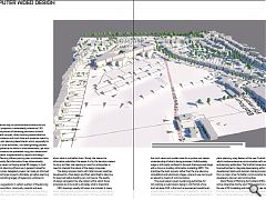
CAD drawings, usually still views, are included in many larger development proposals but are not as yet mandatory within the Scottish planning system. Yet there is little doubt that such views and models make for a quicker and clearer understanding of what is being proposed. Unfortunately, usage is still mostly confined to the post-final approvals stage with a focus on building information modelling (BIM). This prioritises the build process, rather than the pre-planning, consultation and submission stages, where its use can be just as relevant a means of communication.
The usual reasons given by planning authorities for not insisting on submissions being in a 3D format of any kind, let alone CAD, is that such a requirement would be an unreasonable expense to impose on applicants – but this is a misconception. CAD modelling can be especially beneficial in place planning, a key feature of the new Scottish Planning Bill which involves extensive communication with communities and planning authorities. The Scottish Government is urging local authorities to integrate placemaking within their local development plans and decision-making processes and this is a major driver for better communication between developers, planners and communities.
David Wood of Planning Aid Scotland (PAS), a place and active citizenship charity, said: “PAS supports in principle the use of 3D modelling and indeed other new technologies for making it clear to communities and in a visual and easily understandable way what new development is being proposed, be it a planning application, pre-application proposal planning committee or any other relevant scenario. If the technology can be mainstreamed within architectural and planning practice, this should be a positive for everyone.”
A recent questionnaire sent by Urban Realm to 19 local planning authorities revealed support for wider use of 3D modelling within the planning process. Whilst the percentage of submissions made for planning consent in such a manner is currently low and authorities do not insist on it, almost all agreed that greater use (including virtual reality) would help communicate proposals to councillors and the general public.
The consensus amongst those responsible for submitting planning applications and the planning authorities responsible for issuing planning permissions appears to support more 3D modelling in the planning system. However, the use of the latest forms of digital and CAD technology in the planning process has been slow to pick up.
The expectations of the general public are being raised by what they see in the technology media and even TV programmes showing homes using predictive visualisations and walkabouts. We must use the technology in the same way in the process of designing our urban places, towns and cities.
The planning process is very much one of communication and consultation, the need for an understanding of proposals by those who have to be consulted and by those who will give consent in the public interest. Whilst adherence to regulatory factors threads through this process, the outcome is about built forms. Thus the clearest and earliest understanding about what is proposed is vital.
Arguably too much time is spent negatively interpreting the impact of what is proposed rather than in productive dialogue to hone proposals into an environmentally acceptable form. A city like Edinburgh needs constant investment and we will continue to see a largely developer-led planning system enabling that. The use of computer modelling has the potential to diminish the seemingly constant and historic conflict between the development sector and established communities. Only when communities understand what is to be built will they be able to engage with the modelling process and influence what is built.
Place planning is probably going to have to take the place of development planning by councils thus heralding a more inclusive approach to urban development and better outcomes for communities and urban living. Urban design is a discipline, which encompasses architecture, planning and landscape. It involves the design of buildings, groups of buildings and spaces and is, in essence, the process of shaping the physical setting for life in cities, towns and villages. Above all, urban design is the art of making places through the interplay of buildings and spaces which are experienced in three dimensions.
We experience cities as pedestrians, not in a series of fixed views but `as a moving feast of emotions employing all our senses at the same time’. Assessing new proposals for development can only be done if those proposals are presented equivalently.
Designing in three dimensions requires the creation of a model, constructed piece by piece or by parametric means, where the components of the model are pre-specified and then assembled as opposed to being drawn. Autodesk’s Revit is an example of primarily parametric based software, with the model being built in components each having specific and editable attributes. This is excellent for BIM but not necessary or convenient for concept design, pre-planning or context modelling. SketchUp is a more affordable option for most architects and is ideally suited for the planning process.
Jamie Ogston, owner and director of SketchUp partner SEE-It 3D, commented: “The SketchUp model can be viewed and investigated at any stage and with the possibility of the viewer interacting with it. The model can be modified in several ways in response to desirable changes at the viewer’s request. Thus for planning purposes, whether tabled during the dialogue between architect and planner or between the architect and the general public, it is the ideal tool.”
There are also dedicated packages providing city information software solutions for exploring, testing and communicating urban master plans. Some use a palette of standard building types and urban typologies. Others have been created for testing large-scale housing options, which can be demonstrated to planning authorities. Some planning departments are actively involved in these design processes but this is not always the case. However, whether involved or not, what is important is that planning officers should be able to view and interact with such models to influence planning outcomes.
Robert Stringer, owner and director of digital construction data specialists Joanna James, notes: “Often architectural practices can spot a tricky project way before submitting plans. Purchasing a 3D model at pre-application stage alleviates holdups and can save the practice and their client in associated costs of resubmissions. Joanna James recognises more councils throughout the UK are turning to 3D models as a means of supporting planning applications. That said, a common objection has been that planning authorities don’t have traditional software such as CAD and SketchUp to be able to make sense of 3D models. However, we can output, if necessary, via a web-based platform which is as simple to use as Google Street view – no specialist software required, meaning 3D models are for everybody.”
The lockdown has forced home working and certain aspects of this like virtual meetings between multi-home offices, are now an accepted and viable daily feature of business life, so much so that this new intensified form of communication is proving its worth and looks likely to be retained. The advent of interactive environments, often referred to as virtual worlds, which allow the observer/participant to interact with or experience the virtual environment and modify it before making it a reality will accelerate this process further.
Planning departments are still managing to function online and combining this with shared virtual presentations of development proposals using CAD technology can resolve issues of social distancing and geographical separation in the short term but may also prove to be beneficial and convenient for applicants and planning staff in the long-term, especially if remote and home working continues as seems likely. Thus the future for planning authorities might be more shared visualisation meetings at key stages of the planning process shared by committees via video.
Whether cash strapped local planning authorities will make 3D modelling a mandatory part of the planning process in the aftermath of Covid-19 remains to be seen. This will require investment in software and training but that will be outweighed by greater efficiency resulting from improved communication. Pre modelling of our cities is already commonplace but less so is using those same models to test development proposals and to enable a more structured approach to changes and expansion of urban areas and the growth of our cities.
It is perhaps a matter of education and awareness of what is available to both architects, planners and engineers but also to city planning authorities who can feel reasonable in expecting major proposals, in particular, to be submitted within contextual models. What is certain is that within the planning process, communication is all, and 3D modelling is unquestionably the most essential communication tool available.
|
|


